
An interactive map depicting an estimated crash location for B-25 #41-30080 and locations relevant to the escape and evasion of Lt. Edward E. Bailey in December 1943.
UPDATED May 21, 2022. The location of the Australian patrol base at Faita was changed to reflect the location provided by a map found on the mindat.org website. The updated location also reflects my initial idea of where it was located but for which I could find no evidence. The new location is more in line with the hand drawn map in the history of the Australian 2/2 Cavalry Commando Squadron.
Shot up by an enemy fighter over the target at Wewak, New Guinea on December 22, 1943, Lt. Edward Bailey appeared to be having difficulty keeping his B-25 in formation as the 501st Bomb Squadron made their way out of enemy territory. #41-30080 gradually fell several miles behind the formation and was observed to be losing altitude. The pilot gave the order for the crew to bail out but was unable to jump out himself before the plane crashed into the jungle. The last Lt. Bailey saw of his crew was as they jumped from the plane. He could not verify that their parachutes deployed.
A map included in the Missing Air Crew Report states that #41-30080 was flying at 140 miles per hour when last seen. Depending on how much time it took for each crewman to bail out, whether they all jumped from the same escape hatch, and how long before the crash they jumped, their distances from the crash site could vary widely. At 140 mph, each second equates to about 200 feet of travel. If the crew bailed out at five second intervals, there would have been 1,000 feet between each. At fifteen seconds between jumps, the distance between jumpers would increase to 3,000 feet. Add to that the unknowns, such as their flight path, whether they survived their bail out, or whether they moved from their landing spot, the search area for them could become unwieldy.
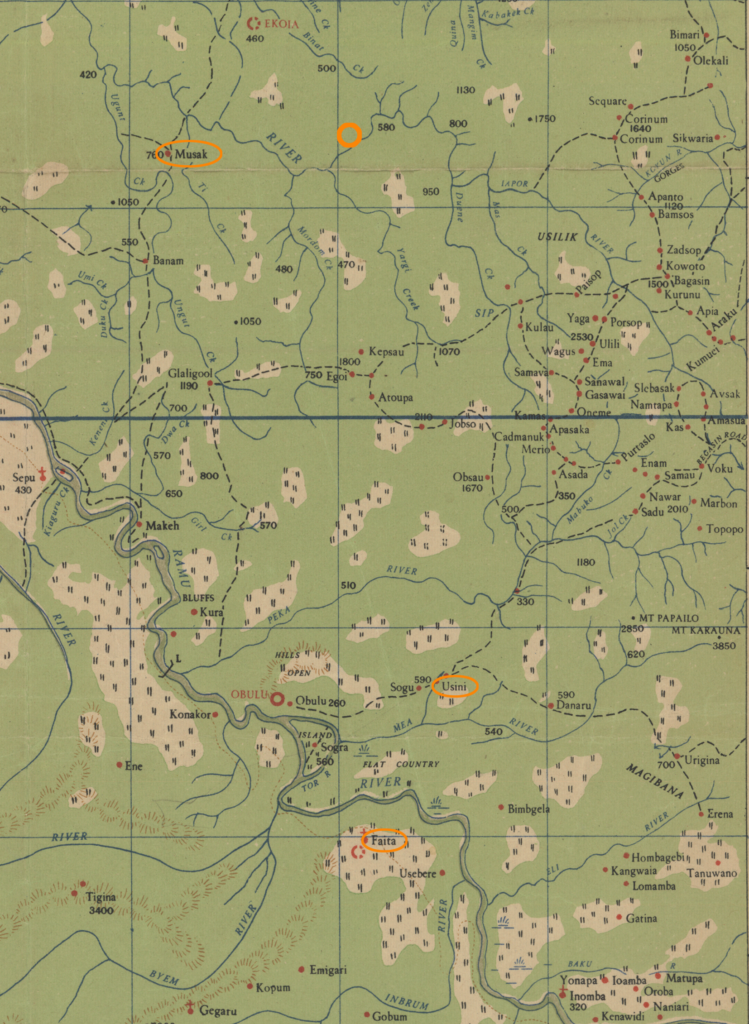
Lt. Bailey came to his senses and then removed himself from the wreckage. At some point, he started walking through the jungle in a southerly direction. On the afternoon of the tenth day of his trek, he met up with an Australian patrol from the 2/2 Independent Company (later renamed the 2/2 Cavalry Commando Squadron) near the village of Usini. Lt. Bailey had managed to travel more than eighteen miles through rough, wild terrain.
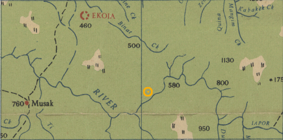
The patrol took him to their base at Faita and then returned to their patrol duties. They managed to find Bailey’s plane wreckage near the Iapon River, about six miles east of Musak village, but could find no trace of the missing crew.
Lt. Bailey spent one night at Faita and was returned to US forces the next afternoon by a small plane (“cub”) that was able to land at the short Faita airstrip.
The Unit History of the 2/2 Cavalry Commando Squadron contains journal entries noting the crash coordinates, their happening across Lt. Bailey, and his subsequent return to military control. It also contains a hand-traced map of their area of operation. I was able to find a digitised version of the original base map sheet for use in this post (1:253,440 4 Mile Strategic Series, Ramu New Guinea, LHQ (Aust.) Cartographic Company, 1942).
The 1942 4 Mile Strategic map was produced from a variety sources, most of them of low reliability and this made efforts to georeference it to satellite imagery unsatisfactory. Instead, I ended up matching up a few river junctions and trail crossings to place the crash site and village locations on the satellite imagery. Not the most reliable of methods, but the results make more sense than the alternative.
One major drawback of the 1942 4 Mile Strategic map is the placement of the Ramu River upstream of Obulu village. According to that map (shown above), the Ramu River makes a sharp turn to the east for about ten kilometers before turning to the south again. The Nopu River, a smaller river that runs parallel to and east of the Ramu, is not depicted and it would seem that the Ramu and Nopu share the same channel for quite a ways.
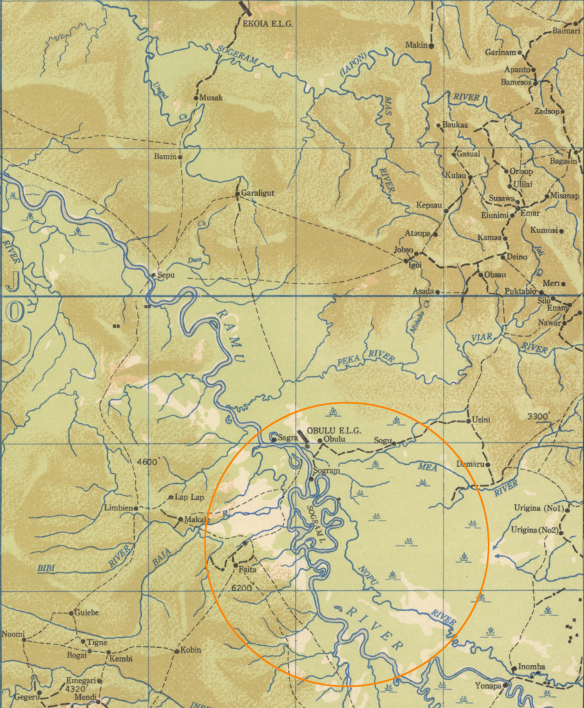
Below is a July 1944 revision of the Ramu map which had been updated to show both the Nopu and Ramu Rivers south of Obulu. The village of Faita has also been moved to the west. The revised map was based on aerial reconnaissance photography and should be the more accurate version. Unfortunately, the grids do not match up between the two map versions, so plotting the crash coordinates directly was not possible.
The crew members involved in this incident were:
- 1Lt Edward E. Bailey, pilot, rescued
- 2Lt Lawrence Griffin, copilot, MIA
- SSgt John H. Brownlee, engineer, MIA
- TSgt Paul L. Thompson, radio operator, MIA
- SSgt Maynard M. Reese, aerial gunner, MIA
While the available Missing Air Crew Report contains a map showing the area where #41-30080 was under observation, there is no post-recovery report from Lt. Bailey that might provide more details. There are four post-war forms, completed by Lt. Bailey while he was stationed back in Columbus, Mississippi, that provide brief explanations of his last contact with his crew. The only discrepancy I noted was that Lt. Griffin is listed as KIA on the MACR while the rest of the crew are listed as “DED”, which indicates a post-war Determination of Death by a military board.
Lt Griffin and Sgts Brownlee, Thompson, and Reese remain on the DPAA Not Recovered list.