
An interactive map showing the targets of the 345th Bomb Group during their raid on Saigon.
By April 1945, the 345th Bomb Group was operating out of San Marcelino, Luzon, Philippines. Some of their mission targets were distant enough that they had to stage out of other airfields in order to have enough fuel to make it back. On April 27, 1945, two squadrons of the 345th flew to Puerto Princessa, Palawan so that they could spend the night there and then fly a mission to Saigon, Indochina.
In a late morning raid on April 28, five airplanes from the 499th and eight airplanes of the 501st squadrons of the 345th Bomb Group made minimum altitude attacks against shipping along the Saigon River in Saigon. The 501st was the lead squadron but their mission report makes no mention of their attack formation other that they were in two plane elements. They were followed by the 499th that attacked in a two-plane, then a three-plane element in trail with a 30 second interval between them.
The 501st mission report offers extensive descriptive text as to which targets their individual airplanes attacked but a mission map was not provided with the copy of that report. The mission report of the 499th contains less text, but has a very descriptive mission map attached.
Several landmarks were used in the 501st mission report to describe locations during the raid. The first was the “large” railroad bridge. Saigon had two types of rail service: a meter gauge line and a light rail or tramway line. The bigger rails crossed the Saigon River about two miles north of the city while the tramway ran more to the west.
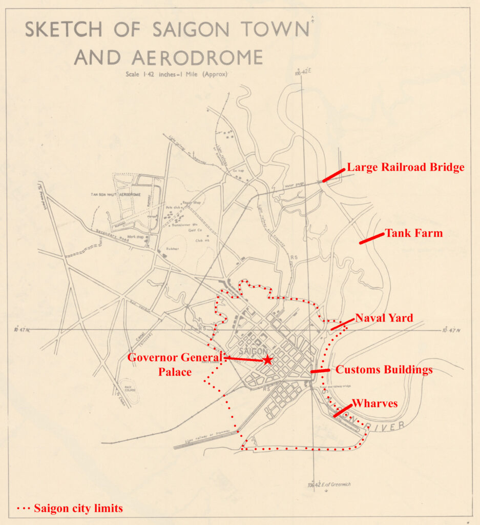
The second landmark was the Standard Oil Company of New York (SOCONY) tank farm north-northeast of Saigon city. As is sometimes the case in the mission reports, east-west directions seem to have been confused as the tank farm is reported to be north-northwest of the city, but the Saigon River runs along the east side of the city of Saigon.
The Naval Yard, Customs Buildings, and Main Wharf were also used in the mission reports to describe the location of targets. The Naval Yard and Customs Offices locations were identified on several 1940’s era maps so I am quite confident of their placement. The entire western bank of the Saigon River Saigon was essentially one long wharf and pier complex from the Naval Yards all the way to the southeast corner of the city limits. The wharf area to the southeast was serviced by a rail spur and there were many warehouses in that area, so my thoughts were that it was used more as the main wharf area than the more downtown section. I used the Governor General Palace as an approximate center of the city in order to place two of the crash sites.
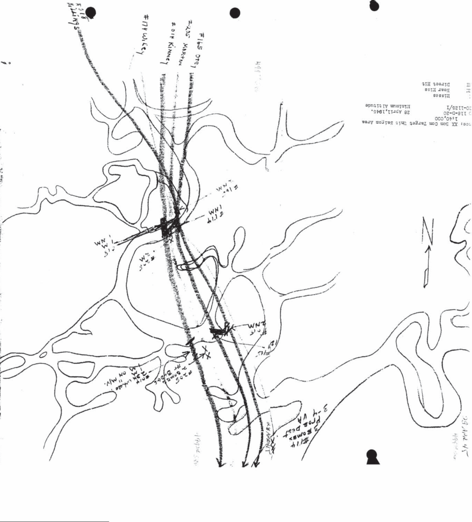
As already mentioned, the 499th mission report relied more on a descriptive map than text to recount their part in the raid. The map that accompanied their mission report was split over two pages, so I photoshopped them back together and then rotated the image so that north was at the top of the map. Once that was accomplished, then the distinctive bends in the Saigon River became apparent and allowed for overlaying on satellite imagery in order to determine the coordinates their targets.
Everett Hatcher sent me scans of four strike photos taken during this raid. At first glance, I thought that if nothing else, they would be interesting historical items to include in this post. The more I studied them along side of maps and satellite imagery, it became clear that they could be matched up to events described in the mission reports.
Along the top of each photo is a strip of printed information that includes the squadron number, bomb group, mission number, date, attack start time, target, and airplane tail number. It also includes a set of numbers, such as 1.0.20 or 3.0.66, that are the frame number of the photo. I am presuming that a lower frame number would indicate it had been taken earlier in the attack. The tail number would pin the action in the photo to a specific airplane. Combining the two helped to place the target along the attack route.

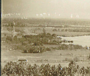
In the strike photo above, taken from airplane 571, a bomb is exploding on the far side of the ship near the river bank. Col. Coltharp attacked several ships during his target run but looking closely at the top left corner of the photo, there is a tower and the course of the river itself is making an “S” curve in the foreground and then seems to have looped back on itself just beyond the sharp bend to the right. Near the tower, there is a small waterway leading off to the left. The frame number suggests that the photo was taken early in the run. The position of shadows suggests that this photo is looking to the north.

I had already found a tank farm to the northeast of the city on a 1968 map of the area but could not be sure it was there in 1945. Then while looking at satellite imagery, I stumbled across a tower standing at the tank farm. With that discovery, along with the waterway leading off of to the left and the shape of the river, I was confident that the strike photo from airplane 571 was showing Col. Coltharp’s bomb exploding against the 500 ton freighter anchored 2000 feet south of the SOCONY tank farm. In the background of that photo, in the top right, are two black columns that would correspond to the two bombs he dropped half a minute earlier on a 200 ton freighter on the north bank of the river.
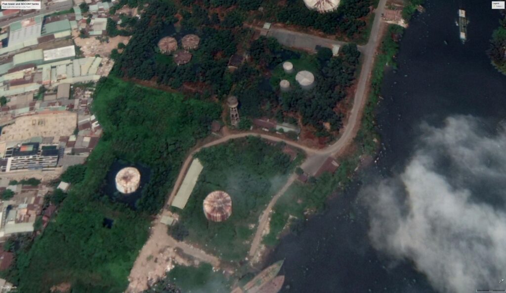
Lt. Hatcher and his wingman had strafed a flak tower located 1/2 mile south of the tank farm early in their run. The tower in this photo was located on the southern perimeter of the tank farm and appears to be a water tower. I chose to locate the flak tower in an empty, grassy space south of the tank farm. While this might be somewhat random, the empty lot appears to have quite a lot of concrete rubble in several piles. Perhaps one day another strike photo will emerge to make a more accurate placement.
A strike photo from late in Lt. Blount’s run shows three bombs exploding on land. Closer examination shows a cloud of smoke or dust in the brush in middle left, which would correspond well with the reported crash scenario of his wingman. The shape of the river is very similar to that near the tank farm in that it shows an “S” curve leading into a tight bend to the right, but there is a road running along this river bank and the tree covered areas and clusters of watercraft do not match up. The frame number 3.0.66 suggest the photo was taken later in the run. I examined maps again looking for another “S” curve bend with a road and also looked for the question mark shaped creek with the bridge in the lower part of the photo. There aren’t many shadows, but the ones present suggest a generally northerly view.
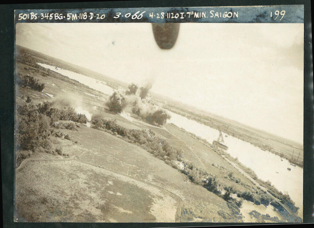
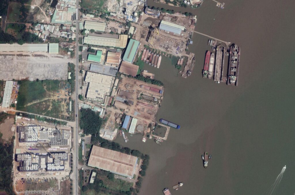
On several 1940’s and 1960’s maps, I found that the shore opposite the main wharf had a road running along the bank and had a question mark shaped creek situated along the bend. I placed the map markers for both Lt. Blount and Lt. Townley to match the strike photo from 199. In satellite imagery, the road is still visible in several places but has mostly succumbed to the apparent erosion of the river bank.
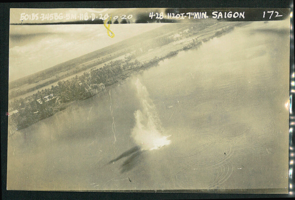
Lt. Jones flew the route alone after his flight leader was shot down right at the beginning the attack. Lt. Jones must have possessed a good amount of resilience and determination because airplane 172 caused a good deal of damage to A/A positions, freighters and buildings as it flew along the river.

The 499th Squadron flew a similar route and attacked the same or similar targets. They also searched out targets of opportunity beyond the Saigon River and did some damage at a small boatyard 6 miles southeast of Saigon. Interestingly, on satellite imagery, there is still what looks to be a boatyard at that location.
The raid was both successful and expensive. Ten freighters and luggers totaling approximately 12,850 tons (1 ton is a 100 cubic foot volume of cargo space) were destroyed, 6 vessels totaling 350 tons were damaged and several warehouses and A/A positions were destroyed. Three airplanes and the fifteen men aboard them were lost. Lt. Esty’s crew in airplane 020 have apparently been recovered and were interred in a group burial at Jefferson Barracks National Cemetery, but the crews of Lt. Johnson’s 041 and Lt. Townley’s 173 are still on the DPAA WWII Not Recovered list.