
An interactive map showing the locations of the earliest missions flown by the 345th Bomb Group in June and July 1943.
Beginning during the last ten days of June 1943, the 345th Bomb Group flew a series of missions that not only performed critical tasks, but also served as orientation flights for the newly arrived pilots and crews; familiarizing them with the terrain and weather of New Guinea.
Some of the assignments were to fly escort and submarine patrols for maritime convoys plying the waters off Port Moresby. Other missions sent them out to gain experience with weather reconnaissance over enemy territory. The most common missions involved dropping supplies and ammunition to allied ground troops operating in the Wau-Salamaua area. These Australian and US Army troops were engaged with the enemy after the allied forces made their invasion landing a few mile south of Salamaua. The supply drops were made to front line locations so there should be no doubt that they were combat missions.
References to these missions were found in the Squadron Unit Histories and on the Form 34 Weekly Status and Operations Reports included in microfilm records. Not all pages of the histories or Form 34’s are legible, but between the two sources a good amount of useful information can be found.
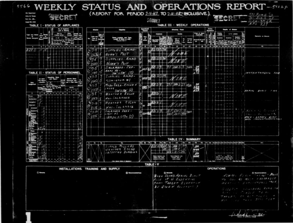
Below is the Form 34 for the 501st Squadron covering the period July 4 through July 10, 1943. Scan resolution is low enough that the smaller print cannot be read, but the handwritten information is generally legible. While Table III contains the information relevant to this post, the form also has data on aircraft and personnel status, bomb loads and fusing, as well as notes on supply and training issues.
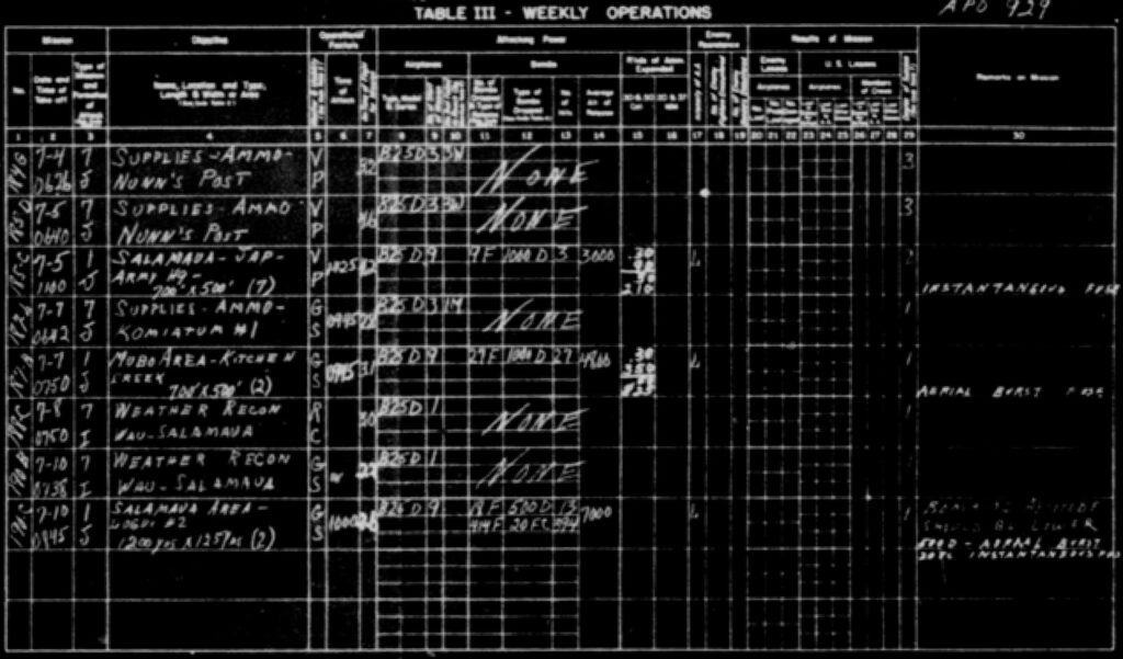
Below is Table III cropped out of and enlarged from the Form 34 above. From these forms, I was able to add missions to the beginning of the Group’s time in New Guinea. This particular table is more legible than the associated text in the narrative history and I was able to correct a location mentioned in a previous post. In my Earliest Missions of the 501st Squadron post, I interpreted the narrative text to read “Mann’s Post”, but on this Form 34, it is apparent that the place name is actually “Nunn’s Post”. A search using the updated spelling produced some results, one of which was a map of the Salamaua area held in the collections of the Australian War Memorial. The location of Nunn’s Post, about three miles west of New Bobdubi, was indicated on that map. It was also a good source for a more accurate placement of the Old and New Bobdubi villages.
Hovering the cursor over this image will zoom into the area beneath the cursor.
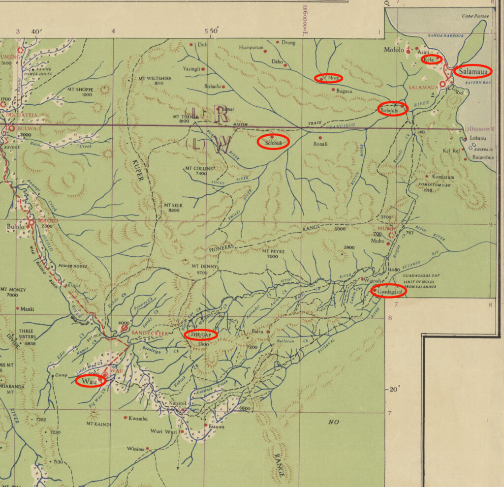
Target locations for the interactive map were determined from several wartime map sheets. The map section shown below is a small portion of the 1942 Australian Army 1:243,440 4 Mile Strategic Series map sheet. Eight of the early target locations are called out on the map and have been cirled in red. Bobdubi village was used as a known base point from which to measure the distance and heading to other targets for locating them on the live map. Hover your cursor over an area to zoom in for greater detail.
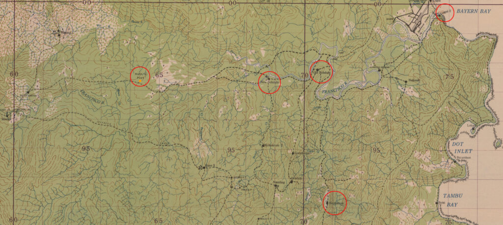
A 1943 Australian Army map was used for locating several other early target locations. The map below is from the 1:25,000 Artillery Series map sheets and was used because it had been updated to show both the Old and New Bobdubi, Logui 2, and Komiatum village locations. The Nunn’s Post location was added to the map from a description of it location being “3 miles west of New Bobdubi” in one of the 345th’s unit histories and from the AWM map. Hovering your cursor over the map will zoom in on the area below the cursor.
Weather reconnaissance missions have been randomly placed near the target destinations. I have not accumulated enough information about weather recce’s to know how close they had to get to a target to be able to accurately report the weather conditions.
The convoy escort missions in the Coral Sea off Port Moresby have been placed randomly within the limits that I came across while reading some mission reports of the 38th Bomb Group, who were contemporaries of the 345th in the Southwest Pacific Area. According to their reports, their escort/submarine patrol missions were flown between Port Moresby and 35 miles to the southwest.
While the mission data for the 345th Bomb Group is still not complete, the addition of these earliest missions helps to shed more light on their time in New Guinea.