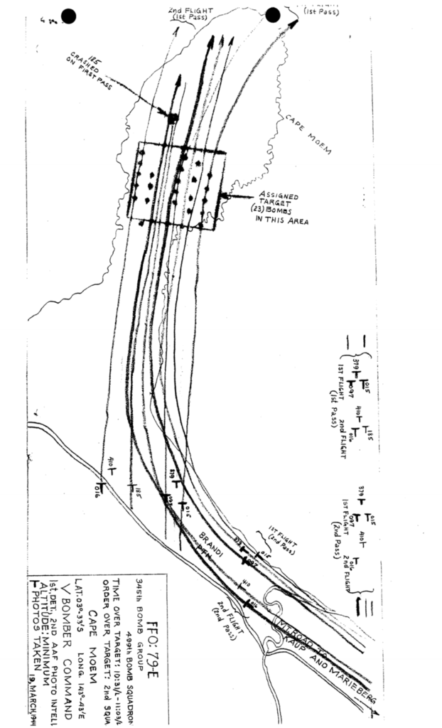
An interactive map of the loss of B-25 #41-30185 on Cape Moem, Wewak, New Guinea on March 19, 1944.
The 499th Bomb Squadron of the 345th Bomb Group flew a minimum altitude bombing/strafing mission to the Wewak, New Guinea area on March 19, 1944. Their assigned targets were storage and personnel areas on Cape Moem. During their first pass over the target, B-25 #41-30185 was observed to roll inverted and then gradually fly into the ground, where it exploded in a flaming impact.
The Unit History of the 499th Bomb Squadron suggests that the cause of the crash was due to flying through the blasts of bombs dropped by other planes of the squadron. The Unit History of the 345th Bomb Group describes the cause as being enemy groundfire. A MACR statement from the turret gunner on the flight lead who eyewitnessed the crash reported that he did not see any explosions close enough to #185 to damage it. A second statement from another aircrew reported seeing three explosions off the right side of #185 and speculated that they were exploding bombs from the first flight.
The mission report states that the planes were loaded with five hundred-pound bombs fused for four to five second delays. An article in the October 2008 issue of Air Force Magazine relates that the lethal blast radius of a WW2 five hundred-pound bomb was sixty to ninety feet. The lines of flight on the mission report map indicate that there were approximately five hundred feet separating the flight paths of the left wingman of the first flight, #097, from that of #185 on the right wing of the second flight.

Whatever the cause of the crash might have been, #185 was captured on film just moments before the crash. The photo is described as showing damage to the right wing (“shredded section” or “wing tip missing”, depending on the source). Enemy machine gun fire was reported by other ships on the mission but very little anti-aircraft fire.
The crash site was positioned by georeferencing the mission map to the satellite imagery. Inconsistencies between the shorelines of the 1944 map and the current satellite image made it necessary to use four of the more pronounced shoreline features as control points. The result was a overall good fit, but some error might be present when zoomed it.
Lost in the crash of B-25 41-30185 were:
- 2Lt Alan S. Anderson, pilot
- 2Lt Clifton C. Roberts, copilot
- 2Lt Walter R. Kellison, navigator-bombardier
- SSgt Paul H. Rains, engineer
- TSgt Frederick F. Dietz, Jr., radio operator
- SSgt Frank E. Younkin, aerial gunner
The entire crew of six is listed on the DPAA Not Recovered web page.
