An interactive map of the area involved in the loss of B-25 #43-36173 on April 28, 1945.
During a raid on shipping on the Saigon River, three B-25’s of the 501st Squadron, 345th Bomb Group, were shot down by anti-aircraft fire. One of those planes was piloted by Lt Vernon M. Townley, who was flying as wingman for Lt. Peppy Blount in a flight of two strafers. Lt. Townley’s plane was hit by anti-aircraft fire during the strafing run leading up to the bomb run and was hit again as it neared the primary target. His plane was reported to have crashed in a small, wooded area about 1,000 feet from the target.
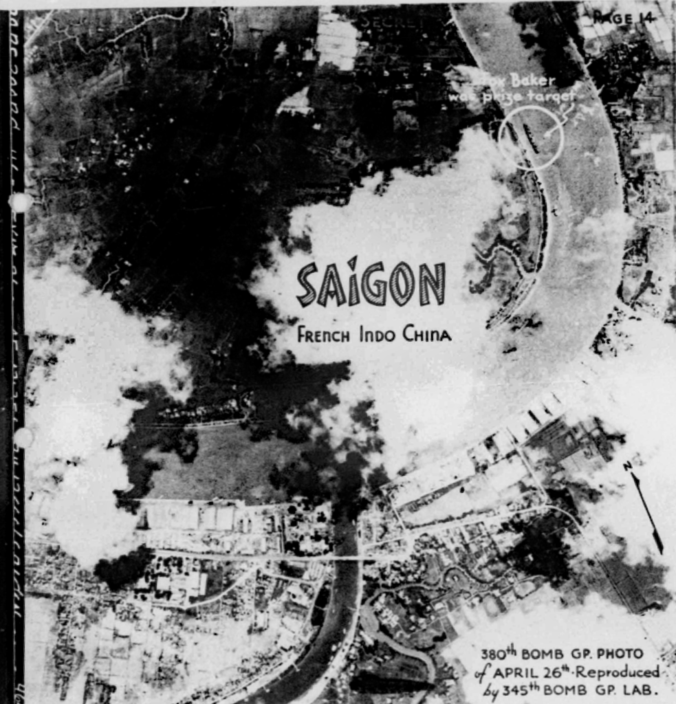
While reading through the unit history of the 345th Bomb Group on microfilm reel B0300, I came across a two-page highlight report of the April 28, 1945 raid on shipping in Saigon. The cover page was a recon photo taken by the 380th Bomb Group two days prior to the raid and showed the location of the 5,800 gross ton freighter that was the primary target of the 345th’s mission. The photo also showed an S-shaped waterway near the freighter and some street intersections that are still in existence today.

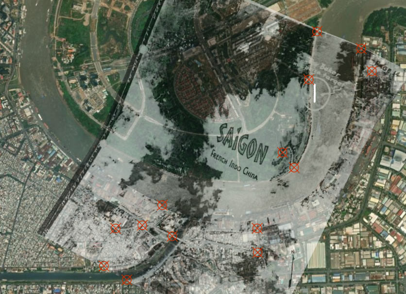
Using several identifiable locations, I georeferenced the recon photo over satellite imagery in order to get an idea of the position of the freighter. I used a transformation method called “Spline” that puts each control point exactly where it is placed and then stretches the photo between it and nearby control points to make the photo fit the imagery accurately. The spline method seems to work well for me when photos were not exactly taken vertically or when there aren’t enough suitable locations to use as control points in all four corners of the photo or map.

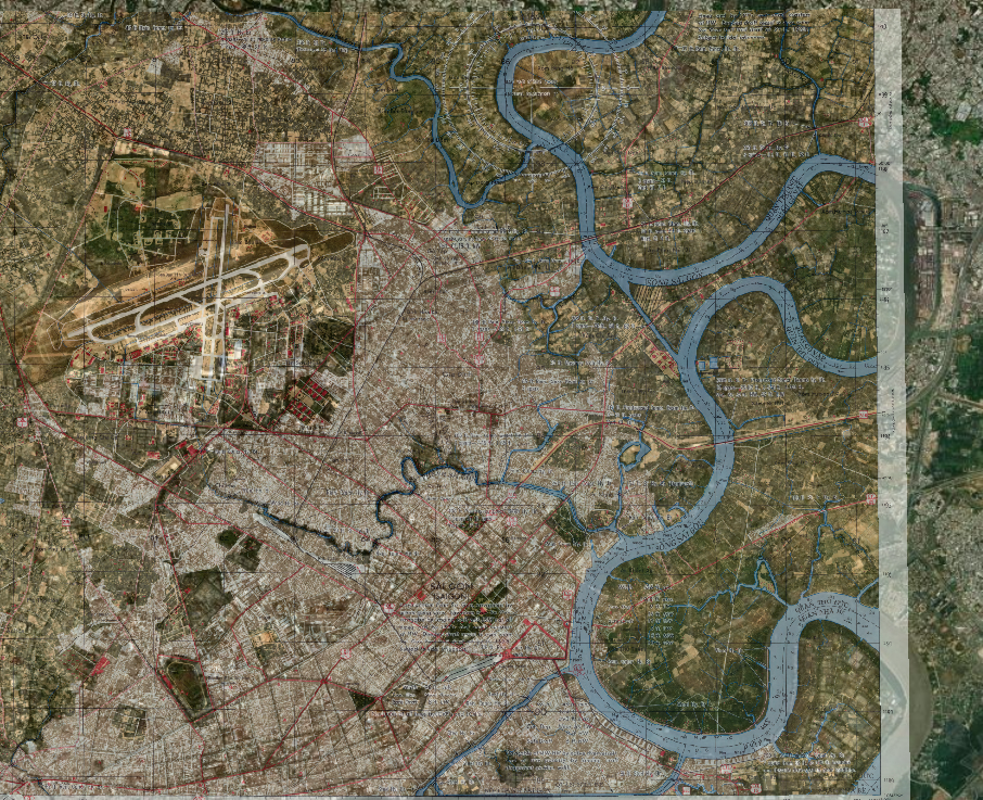
While I was unable to obtain a WW2 era map of the Saigon area, I did find a 1965 version of the Series L8020, 6330-4-S, 1:25,000 scale Army Map Service pictomap (a hybrid of a topographic map and aerial photography) that covered the Saigon River flowing along the edge of the city. This map provided some needed detail to the areas near the main wharves and the crash area.
The pictomap was georeferenced using the “2nd Order Polynomial” transformation method, mainly because there were many widely dispersed road intersections available to use as control points. Just how the transformation works is unclear to me except that it involves mathematical wizardry beyond my comprehension. It can do a great job of aligning images with enough common features.

Everett Hatcher, son of Ollie Hatcher, sent me some stike photos from his father’s collection. One of them was taken from the rear camera of the B-25 that had managed to hit the primary target with bombs. The photo shows explosions in the background that obscure the freighter but also shows a smaller dust cloud in the middle left at a bend in a tree-lined waterway. Narrative in records of the 501st Squadron mention that this could be the crash location of the plane piloted by Lt. Townley.

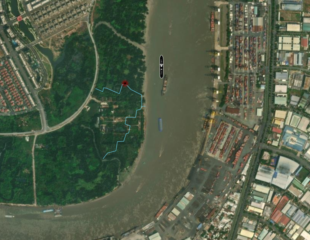
After some consternation regarding discrepancies in the positions of the river bank and canal features, it dawned on me that the left (west) bank of the Saigon River had undergone enough erosion, or intentional removal, that the small road and wooden bridges shown on the photomap had been consumed by the water. Once this was recognized, the small canals prominent in the Hatcher photo (I came to refer to them as the “T-shaped canal”) could be located with more confidence.

After enough scrutiny, the woodlines marking the small canals in the lower half of the Hatcher photo began to stand out in the satellite imagery. At that point, I was confident enough of my interpretation that I placed the proposed crash site on the outside of the northern-most curve that the upper canal performs before it joins the outlet to the river.

Lost in the crash were:
- 2Lt Vernon M. Townley, Jr., pilot
- F/O Hilbert E. Herbst, copilot
- 2Lt Robert L. Burnett, navigator
- Cpl Seymour Schnier, radio operator-gunner
- Cpl Harry Sabinash, mechanic-gunner
The entire crew of five remains on the DPAA Unaccounted For listing.
