Early on the morning of January 9, 1945, B-25’s of the 500th Bomb Squadron took off from Tacloban, Leyte on a mission to support Allied invasion forces near Camiling, Luzon. When their support was no longer required, they set off for their secondary target, which was railroad rolling stock between the villages of Paniqui and Malolos in central Luzon.
This account is very different from the post regarding the crash of Lt. Browngardt two days earlier. As much accuracy as was possible in pinpointing that crash site, this crash is based on the observations of the lone survivor, hearsay, and some unverified old maps that may or may not accurately portray the positions of villages and airdromes in the area. Technical Sergeant Walter J. Nelson, the radio operator on airplane #43-36187 and sole survivor of the crash, made a detailed report on his return to military control. His account is presented as the best portrayal of his experience.
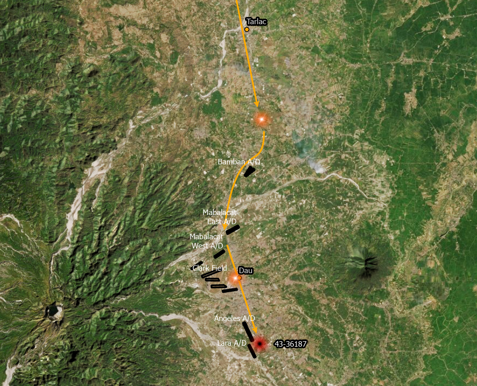
According to Sgt. Nelson’s account, his pilot, Lt. Buffington, separated from a flight of three planes and turned back to the north when they were 8 miles south of Tarlac in order to attack two trucks he had just noticed. They then headed back south in order to catch up to their flight, but again turned around to attack two stationary trains at Dau. Immediately after that attack, their airplane was hit by anti-aircraft fire causing a fire to break out in the cockpit and navigator’s compartment, and they bellied in on a rice field quickly thereafter.

Sgt. Nelson was thrown clear of the wreckage and when he came to, the first thing he noticed was several enemy airplanes parked under trees 1500 yards to his west. He then attended to the wounds of two other crewmen and observed one corpse near the wreckage. After applying a tourniquet to his own leg, he left the site to find some help in a group of huts several hundred yards away.

Filipinos in those huts took him in and set out to rescue the other crewmen but had to turn back because Japanese soldiers had already arrived at the crash. That night, the Filipinos were able to reach the wreck, but found the crewmen dead.
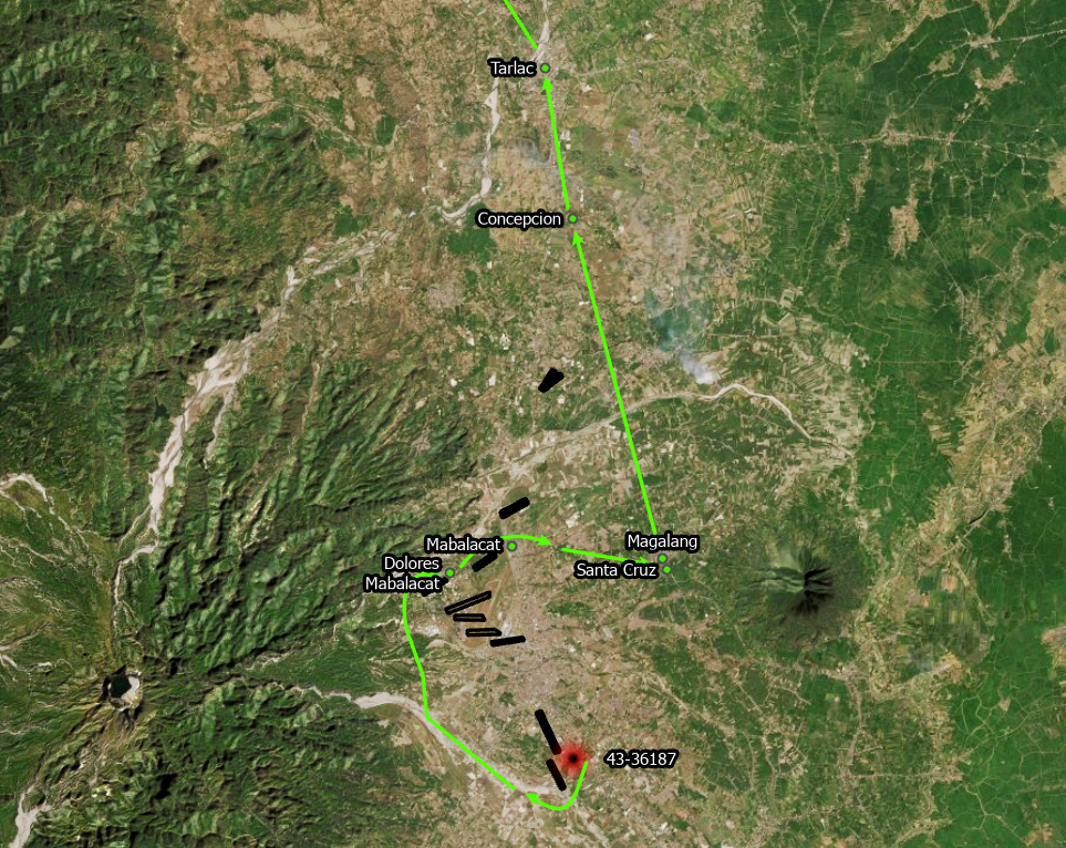
The next night, Sgt. Nelson was carried to the village of Dolores Mabalacat where he recuperated for ten days. During the daytime, he was kept in a treed area and at night he was returned to the village. From a tree in his daytime spot, he could see Japanese troops destroying the runways at Clark Field.

On January 20th, Sgt. Nelson was placed in the care of local guerrillas and they walked to the east through tall grass and rice fields. They spent a night in a village just south of Magalang, perhaps Santa Cruz, and then moved to Magalang the next day. Magalang was described as the headquarters for the local guerrilla battalion.
On January 22, he set out with the guerrillas north toward Concepcion, but they turned back in order to take on two more US airmen who had crashed near Clark Field. One of them was Captain Frank C. Hogan, of the 312th Bomb Group whose A-20 had been shot down while attacking the Mabalacat East airdrome on January 7.
They set out toward Concepcion again the next day but were once more turned around when they received word that American forces were approaching the Magalang area. The airmen were turned over to the 640th Armored Recon unit who drove them to Concepcion. The next day, Sgt. Nelson was taken to the XIV Corps headquarters at Tarlac and from there he hitchhiked to the 308th Bomb Wing at Lingayen in order to catch a flight back to Tacloban with a 345th airplane on January 25th.
The location of the crash site is not meant to imply accuracy. It is based on a comment in Sgt. Nelson’s report that someone told him later “that he was near the Angeles South (Lara) strip” and that he saw two twin engine bombers 1,500 yards to his west. It was common for airplanes to be dispersed around and between airstrips. The Angeles airdrome appears to have been the longer, and therefore more useful to bombers, of those two strips. Combining those two pieces of information led to the placement of the marker to the east of the north end of the Lara airdrome. I purposefully used a large, blurry map dot to indicate the uncertainty of the location.
Also, the line of flight leading up to the crash and the escape routes have no inherent accuracy. Both are only seemingly logical routes that could have been taken between locations mentioned in the various documents.
I am more confident in the location of the Dolores Mabalacat village as it was shown on a 1944 Army Map Service topographic map and, thanks to a thorough explanation of Philippine place-naming conventions from Ron Beattie, it differs from other villages named Dolores in the general area in that it is the closest to the town of Mabalacat. It is also close enough to Clark Field to observe soldiers working on the runways.
In all, this attempt at showing the crash location is, at best, an effort to place it on a live map for reference and remembrance.
I think it is a testament to the tenacity and resourcefulness of the Filipino people that they were able to rescue and care for downed airmen in such close proximity to Japanese occupied airfields. Many 5th Air Force men owe their lives to them.
Lost in the crash of airplane #43-36187 were:
- 2Lt James O. Buffington, pilot
- Capt Richard T. Thompson, copilot
- 2Lt Vernon C. Buchanan, navigator
- Cpl Bernard R. Dunnavant, engineer
- Cpl Joseph Hertz, aerial gunner
