

During February of 1945, the 345th Bomb Group moved from Tacloban, on the Philippine island of Leyte, to San Marcelino, north of the Bataan Peninsula, on Luzon. Some of the first missions flown out of San Marcelino were in support of ground operations to their south near the village of Bagac.
From February 15 through February 18, at times working with the Air Liaison Group on the ground, the 501st Bomb Squadron made low level bombing/strafing attacks along the Bagac-Pilar road. The mission reports are somewhat unique in that they reference map grid coordinates for the target areas instead of latitude/longitude coordinates. The map series used in the attacks is referenced in the mission reports and those maps are available online. Mission maps were not included with my copies of the mission reports, so having the map and grid coordinates allows for an accurate depiction of the missions.

The Bagac-Pilar road runs along the top third of the map sheet, so I cropped the map to allow for a more detailed view of the plotted target areas. The red numbers were added to reference the grid coordinates. Multiple passes over the targets were made and were flown from east to west, possibly because friendly troops were operating along the eastern end of the area.
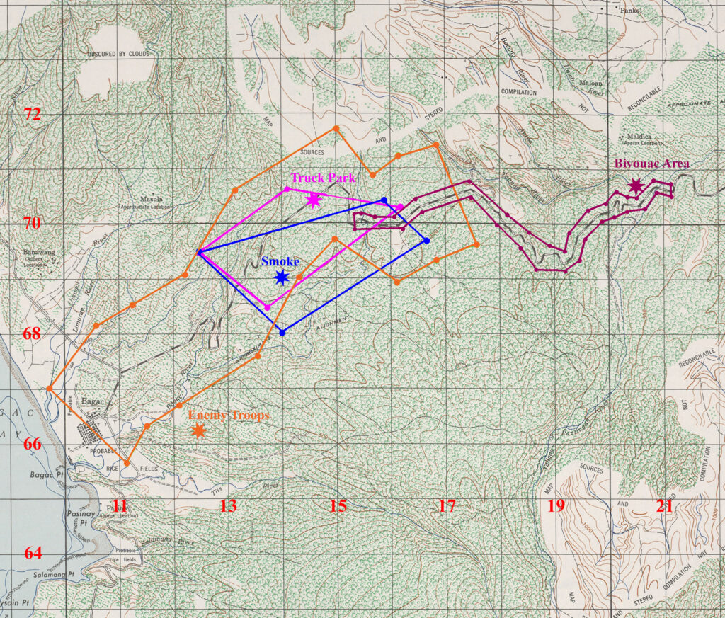
The first mission was flown by three airplanes on February 15, 1945. On the map above, the targeted area is shown in dark red and included eight strafing runs along the sides of the roadway after dropping their six 1000 pound bombs on a bivouac area. As is usual when using time delayed bombs in terrain covered with dense forest, results of bombing was not observed.
On February 17th, shown on the map in orange, six airplanes attacked targets of opportunity along 2,000 yards of both sides of the western section of the road all the way to Bagac. The only observed result of this mission was catching some enemy soldiers in the open and several small grass fires.
Two missions were run on the 18th, one in the morning (shown in blue) and another in the afternoon (in fuschia). The morning objective was to destroy enemy supplies and troops along the roadway and was bounded by box of four grid coordinates. Six airplanes made five passes over the target area. Several columns of black smoke resulted.
The afternoon mission had the same objectives and was bounded by an overlapping box somewhat to the north of the morning mission. Six airplanes made three passes over the target area. One of the bombs landed among a group of 10-12 trucks parked under the tree canopy with unobserved results.
Plotting the target boxes onto the digital map of Bagac, I then used that image to georeference the map sheet (Luzon 1911 datum) to a WGS84 basemap in ArcGIS. The image below shows a piece of the map sheet overlain on a satellite image during the georeferencing process. Distinctive bends along the Bagac-Pilar road were used as control points as well as one distinctive intersection in Bagac itself.
A portion of the 1944 AMS map sheet with the target boxes marked on it overlain on satellite imagery. Digital copy of the original map sheet courtesy of the Perry-Castaneda Map Library, University of Texas at Austin.
The finished product. The targeting data transfered from a WW2 era map sheet to satellite imagery.
These rare occasions when mission reports and referenced map sheets are available make for interesting mapping. Guessing and hypothesizing can be replaced with more accurate location data for a more definitive look at a brief period in history.