

Early in my research, just after my search efforts started to bear fruit, I was put in contact with Vic Tatelman of the 345th Bomb Group Association. Vic had been a pilot with the 499th Bomb Squadron and as the keeper of the documentation for that squadron, he sent me a copy of the 499th’s mission report for 21 May 1944. While there was no mention of a missing 501st airplane in the report, there was a detailed description of damage done to one of their airplanes by a machine gun located southeast of the But airdrome. In the sightings section of the report, there was mention of a crashed twin engine airplane on the side of the ridge near that machine gun location. That sighting stuck in the back of my mind as an interesting aside for years until recently when another mapping project caused it to become an important incident.

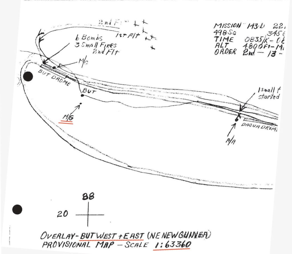
Despite the considerable damage to one of their airplanes, the 499th’s mission map did not make note of the location of the machine gun southeast of the But airdrome. In the mission report of the 498th Bomb Squadron for the following day (mission 143-D), which was another raid on the But and Dagua airdrome areas, they had encountered accurate, damaging machine gun fire that originated from the area southeast of the But airdrome. Their map for that mission had the location marked and annotated. While the machine gun position certainly could have been moved overnight, the description put it in the same general position as the day before. I also assumed that there would be a limited number of suitable places on a cliff side in which to place a machine gun and crew.
Because the mission map was made as a tracing from an original base map, aligning these two maps would be a matter of enlarging/reducing the overlay until it was the correct size to match up with the base map.
Fortunately, this mission map included information about the base map used for the tracing as well as a cross mark indicating a grid line intersection for a known location on the base map. As luck would have it, a digital copy of the base map (But West, 1:63,360) was available online so that, using Photoshop Elements, the mission map could be overlain on the base map using the 20/88 cross mark, But village, and the coastline to align the two. Once alignment was attained I added a small red star over top of the mission map machine gun location so that it would also be in the same location on the But West map when the overlay was removed.

As is the usual case, a location from an old map cannot be plotted directly onto a satellite image because the landmarks do not align no matter how much the old map is reduced or enlarged. Also, the 20/88 cross marks aren’t valid as a known location on satellite imagery. In an attempt to overlay the topographic/mission map image on Google Earth, I used the spacing of the map’s grid lines, which is 1000 meters between lines, to enlarge it in Google Earth until a 1000 meter reference line drawn on the satellite image matched up to the grid on the old maps. Is this a 100% accurate method? Probably not, but it is all I could think of to use and is certainly closer than just lining up the coastline. (I had done just that in an earlier attempt to put a location to this crashed airplane sighting.)
As part of my shaky understanding of maps, satellite imagery, coordinate systems and map projections, this problem of locating a point from a map onto a satellite image is just like the problem you would have if you had a small map of the U.S.A on a piece of paper and you tried to overlay it onto a globe. You might align one point to begin with, but soon you would find the paper wrinkling or tearing in order to make other places on the map line up along the curved surface of the globe. You would be losing places in those wrinkles in the map and the end result would not be very satisfactory for navigating. The various projections used to produce maps stretch and shrink the view of the globe surface so that all the land is accounted for, but might sacrifice accuracy in shapes, direction, or distance in order to do so.
From this point, the geographic coordinates (in the WGS-84 geographic coordinate system) can be obtained for the machine gun location from Google Earth and are -3.392962° 143.230035°. These are the type of coordinates that could be entered into a GPS to get a visitor to this location.
Using the But West topographic map without the mission map overlay, the machine gun position marked by the red star south of But village is located on a 500 foot elevation contour. Gunners firing from this elevation would have had the distinct advantage of firing down onto strafers that were flying at minimum altitudes that were often at tree top height. Up until this point, enemy fire had usually come from ground level below the altitude of our airplanes. This change in the Japanese tactics was expensive to the 345th until it was recognized and accounted for in their mission planning.

By removing the overlays, the machine gun location can be seen from directly overhead in this satellite image. Data accompanying the imagery confirms that the elevation of the machine gun at about 500 feet above sea level. That would indicate, to me, that the method used to locate the map pin might have some validity.

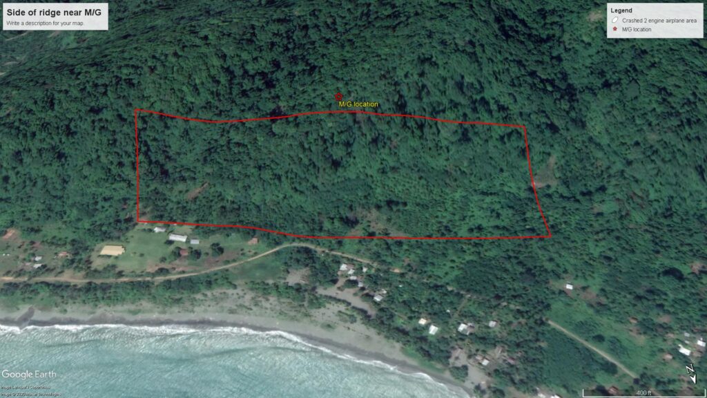
Tilting the view of the satellite image, and looking from the north, a red box can be drawn to highlight the side of the ridge near the machine gun. The box encloses about a square mile of rough terrain of varying incline. It could be a tough area to search for wreckage that could just as well be farther east or west outside this box. If the crew observing the crashed airplane were flying at minimum altitude, that might reduce the height of the search box since their vision would have been limited by thick vegetation. The crashed airplane was described in the sightings section as being “near” the machine gun position. Not knowing if their definition of “near” was measured in feet or hundreds of yards makes a potential search area much larger.
There is a known source of error associated with this attempt to plot the location of a point from an old map to satellite imagery. I noticed that the land features on the overlain But West topographic map were less well aligned to the imagery as the distance from the alignment points grew. Specifically, the location of the Ninahau River southwest of the But airdrome (near the Muguluwela village) had not been overlain as closely as the But village and But River had been. Some of the discrepancy could be due to changes in the course of the river over the past 70 years, but whereas the But River aligns within 50 meters, the alignment of the bends in the Ninahau River are no closer than 500 meters. This is something I will continue to investigate and will look for different methods of overlaying the topographic map over the satellite imagery.
I have been unable to find any Missing Air Crew Report or other documentation that mentions the crash of an airplane on this ridge. There are, however, several MACR’s for two engine airplanes that went missing without a trace that could have been in this area.
This is my interpretation of the data I have to work with. If more information becomes available, this post will be updated to reflect any warranted changes.